Arrangements had been made for today with Tom, meet Kingsway End, 9.30am. Up at 7am, I was on the road at 8.10. Rain came down spasmodically, but not enough to justify the cape, and the morning was as wild as could be wished. A gale was blowing the black clouds across the sky with great force, and the cold wind cut like glass. Happily, it was dead behind, sending me along at a fine pace to Barton Bridge, where I was held up by a huge ship, the ‘Governor’ of Liverpool – inward bound, for 15 minutes. A lane route led me to Stretford, then the residential suburbs of Chorlton and Didsbury, and at 9.35, Kingsway End. Three minutes later Tom rolled up, and then we started along Wilmslow road, through Cheadle.
Very little traffic was on the road, the weather having, no doubt, driven all but cyclists off. At Handforth, we turned into the lanes towards Prestbury, and from then (10am) until reaching the same road at Monks Heath – 4.30pm – we did not see more than three motor vehicles, and not half a dozen cyclists! And then our roads are over-crowded! The wind sent us scudding down the lanes with rare ease to just above Prestbury, where another byway took us across the deserted Stockport-Macclesfield road, and dumped us into Bollington. Now we were amongst the hills properly, and heading towards the highlands.
Ahead, our road could be seen appearing and reappearing like a brown line high up on the hillside. The gradient got too steep for us, and in half a mile, climbed up about 400ft, the views of the Cheshire plains behind being extensive, but spoiled by the mists. Another rideable mile, then up again, walking to the Whaley Bridge-Macclesfield cross roads at Patch House. Just beyond here, we reached 1,260ft. Distant views were spoiled, but the hill views were wonderful.
On our left was a brown-green moorland valley, with numerous black stone walls dissecting it into sheep fields and folds. The swelling ridge beyond was a mass of such walls, whilst a glistening metalled road cut through it. Stony brown tracks between walls wound tortuously over the ridge, and the swift black clouds seemed to touch the very hills. On the right, a steep clough carried a rushing stream under the shadow of low rocks, beyond which the knife-like edges of the moors appeared mistily, and the peak of Shutlingslow (one of the few real peaks in Derbyshire) climbed into the clouds, far away, so it seemed.
We started to drop a little now, to Blue Boar Farm, just beyond which, we stopped at an old disused road. We asked a farmer who happened to be there, if this was the road leading over to Goyt Bridge. “Aye” he said, “this is it, but go careful, there’s a bad drop to the valley coming. Yer moant try ter ride it, yer know, fer if yer brakes go there’s no stopping, a life’s a life, an’ that’s a bad drop yer know”. “If yer ‘ave good sound brakes, doan’t ride it. Yer life’s yer life yer know an’ there’s no stop. If I wuz yer, I would go on fer a bit and tak’ that other road, it comes inter this, and yer can ride. Aye, it’s a bad drop, an’ its just past that bend”.
Tom, scenting something unusual in gradients, suggested that we go, and I was keen on it. We bade the genial old chap good morning and mounted. The last words of the old chap as we rode away were: “Yer life’s yer life yer know an’ it’s a bad drop”.
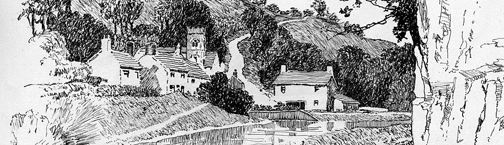
Turning that bend, we came upon the ‘drop’. He who even takes a perambulator down there must have hard work to hold it back, and he who tries to ride a bike down is either suicidal or a lunatic. The road was very loose, and full of impossible bends, each bend being at a less gradient than 1 in 3. Right across the valley was our proposed road, climbing in long steep pitches to the summit of a spur of Cats Tor. It is hardly necessary to say that we did not ride down this freak hill. There was a little watersplash at the bottom which we rode through, then we started on the long tramp up the other side. The gradient at first was very steep, but it eased off a little later, and we came across the queerest church that we ever saw. It was an uncommonly plain, rough stone structure, with a square tower at the west end.
At first, one would think that this – Salterford Chapel – was of considerable antiquity, but it was only built in 1733. The side windows are of plain glass squares, just as is seen in wooden shanties or builders huts, but behind, are some painted glass windows, protected on the outside by wire. Wooden steps on the outside give access to the tower. We could not get inside, but caught a glimpse through the windows, of a tiny, clean room, whitewashed, and neat rows of simple pews. It was all so rough and ready, and inscriptions on the outside give some detail of it. I forget what they were.

As we climbed higher, we discovered faint traces of snow. At length, after a long, arduous ascent, we reached the summit, 1,379ft above sea level. Here was a view behind of wild, uncultivable moorlands, of wind-swept ridges, and of cloughs, some barren, some wooded, but with bare, black trees. Brown steep roads wound across, with many a sudden lurch into desolate cloughs, and many a tortuous climb. The floating clouds swept across a lowering sky, and here, one could lean on the shrieking wind:-
‘Better than mortar, brick and putty,
Is God’s house on a blowing day’.
A little farther along, another wild road branched off, skirting the sharp summit, and wandering away towards Whaley Bridge. Our road here ran by the side of a bleak pine wood, and started on an easy descent. The map marks Pym Chair as a ‘sight’ hereabouts, but we could see nothing of it. Of course, it isn’t what its name suggests, and I don’t know what it is, but I take it for a mound, earthwork or tumuli. Perhaps I shall be enlightened yet, but so far, though I have heard much mention of it, enquiries have failed to find out what it really is. [Its just a hill – Ed].
Our road now joined that Roman Highway, The Street, and continued as Roman roads generally do, in a straight line, towards the valley. The surface was atrocious, where it wasn’t axle deep in mud, it was littered with huge boulders and sharp stones. We made much progress, however, and were just speculating on the wants of the inner man, when a ‘Teas’ notice attracted us. A track led us to Errwood Farm, where lunch was soon ready – and soon disposed of. From the window, looking across the valley, we marked the line of the Stockport-Buxton road, climbing first on the hillside, then disappearing where it describes a huge horseshoe, reappearing high up on the summit, at an altitude of 1,401ft, just before it dips into Buxton. The room was too cold to linger in, and we were soon on ‘The Street’ again, dropping through pleasant woods to Goyt Bridge.
Here, the River Goyt falls in a wild little cascade, making a formidable watersplash on the edge of a road, which, happily was not ours. Goyt Bridge is a rough, stone structure, well in keeping with its rugged surroundings. No motors ever come down here, for the three of the four roads leading to it are far too precipitous for them, and the fourth is closed to motors. From Goyt Bridge, we started to climb up the sheltered, wooded valley. What a change! As we got higher above the river, we looked down through the pine and fir trees – Christmas trees – at the silvery, rock strewn river, descending in many little cascades and falls. Tom compared it with the Trossachs up in Scotland. First uphill, then level across little heaths, with the babbling river below us, until gradually we left the woods behind.
The desolate moorlands came into their own, and the winding road became stony and steep, whilst the river was now but a tiny stream beside us. After some glorious uphill miles, we came to Derbyshire Bridge, and emerged from shelter, on the Buxton-Macclesfield road, opposite the Congleton turning. The force of the wind at this height – 1,630ft – was terrific, and the scenery about us was enough to strike awe into the hardest heart. From this point, our roads diverged.
One was a rough brown byway, leading right, away over the moors. This joins the Buxton-Leek road, and leads over Axe Edge, being as wild a road as can be imagined. The other, the Congleton road, was just as wild, with savage drops and sudden climbs. We had traversed about four miles of it earlier, in the opposite direction, and the tendency of the road had caused us to walk almost every inch of those four miles. For a while we had half a mind to keep the wind behind us, and go over Axe Edge, but we decided that it would be too far. We never dreamt of taking the Macclesfield road, which would have meant a six and three quarter mile descent into the silk town. Instead, we chose to face the wind, and tackle the gradients of the Congleton road. After a short struggle for about half a mile, we stopped a minute to take in the full grandeur of the moors.

What lay before our eyes was indescribable. Before us, the brown road leaped up and down, disappearing round a bend to reappear like a ribbon far away on some steep hillside. Tracks led away over the wild waste, or were lost in some deep gully. Right away beyond the desolate expanse of bracken and turf, were a range of rounded summits, misty and unreal, whilst between them, the black moors led away out of sight. At the end of the range, on a stormy jagged rock pinnacle, indistinct, but unmistakable, Hen Cloud.
On three sides were clouded, wind-swept ridges, and as far as the eye could see, the distorted, riven desolation stretched, beneath a seething sky. People who wonder why one can get lost in Derbyshire should come here, where no habitation can be seen, and where man’s handiwork consists of the contoured roads, a black, worked-out quarry, two or three roofless huts and a line of twisted, ruined metal rails. It made us – two puny, insignificant creatures – feel small and lonely, with the hoarse voiced grouse and the roaring wind shouting mocking taunts.
We got a move on, and pedalled hard to make headway downhill. When we reached an exposed position, the gale would sweep us half across the road. For two and a half miles we pushed on, then joined a downhill road through a wooded clough for a mile to Wildboarclough. The road took us by the stream down this romantically named vale – so named because the last wild boar in England was caught here, then uphill, leaving this road here, and once more facing the wind up a steep hill, until we stood at the summit, with the plains of Cheshire at our feet.
Again sheltered, we dropped off the Roof of Cheshire to Sutton, then many bylanes led us across the Macclesfield-Leek road near Bosley to Gawsworth, on the Macclesfield-Congleton highway. We seemed to have left the wind on the moors, for no more did we notice it, and the peaceful tranquillity of the Cheshire countryside was undisturbed. Via Henbury in the lanes, to Blue Bell Valley, then up to the Macclesfield-Chelford road, then Monks Heath and Alderley Cross for tea in the pleasant, calm twilight.
At 6pm, we were on the road again, pottering through Wilmslow to Handforth, then Cheadle, and the circuit was complete at Kingsway End. We had a long chat, then made arrangements for next weekend, each then going his own way. I returned the same way as I set out, arriving home at 9pm, beneath a bright, clear sky. Today has been wonderful, and rainless, although everyone says it has rained all day! We were travelling with a patch of blue, however, and that may account for it – although the patch in question was hardly discernible, except to the optimistic eye. Beside the fact that rain and motors were conspicuous by their absence, we had the extraordinary luck to have the wind behind us for over 45 miles, less that 12 miles against. When we should have fought it, it dropped! I am beginning to think now that it really “Aint gonna rain no mo’,” for I have not ridden above five minutes in rain this year – over a month ! 92 miles
Pingback: Windy and Cold ! | Charlie Chadwick